

You're now following
Error following user.
This user does not allow users to follow them.
You are already following this user.
Your membership plan only allows 0 follows. Upgrade here.
Successfully unfollowed
Error unfollowing user.
You have successfully recommended
Error recommending user.
Something went wrong. Please refresh the page and try again.
Email successfully verified.

cairo, egypt
It's currently 7:15 PM here
Joined September 3, 2015
0 Recommendations
Amr S.
@amrsamiserag
4.1
4.1
0%
0%
cairo, egypt
100%
Jobs Completed
100%
On Budget
100%
On Time
N/A
Repeat Hire Rate
GIS Data Processor, Cartographer
Contact Amr S. about your job
Log in to discuss any details over chat.
Portfolio
Portfolio
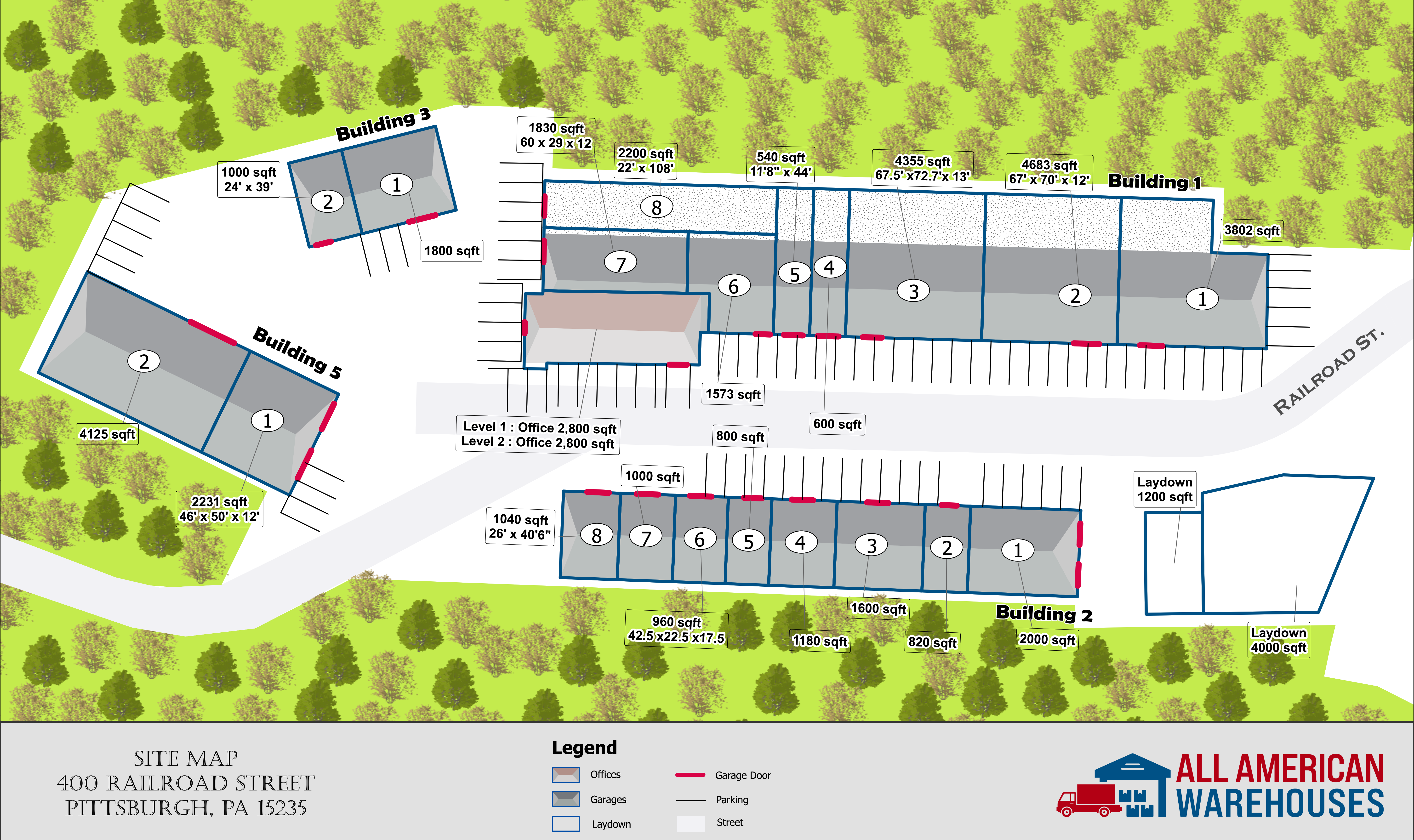

Site Plan Illustrator for Storage Facility


Tourism Maps
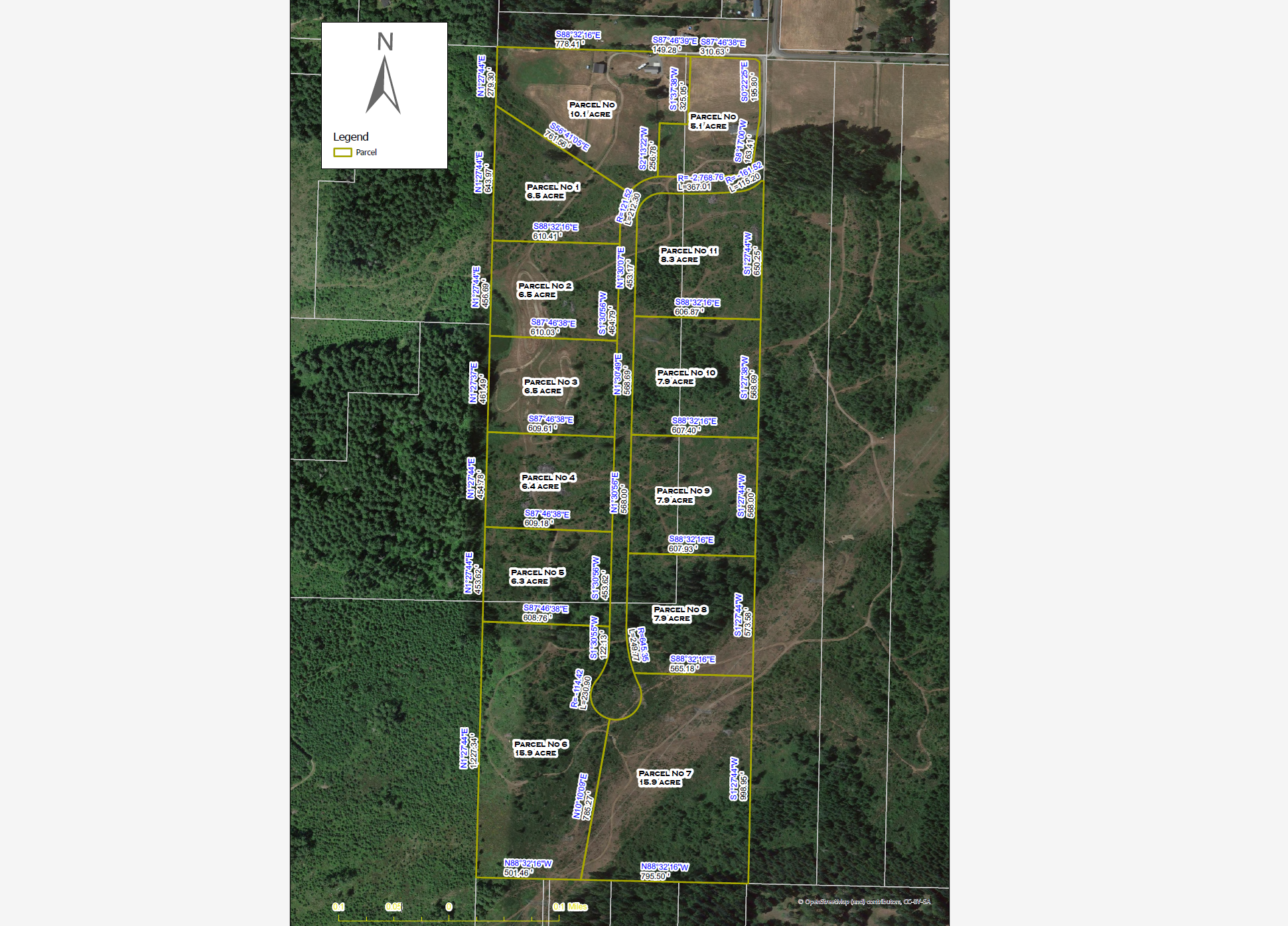

Site Plan for Development Land

Site Plan for Development Land

Site Plan for Development Land

Site Plan for Development Land

Site Plan for Development Land
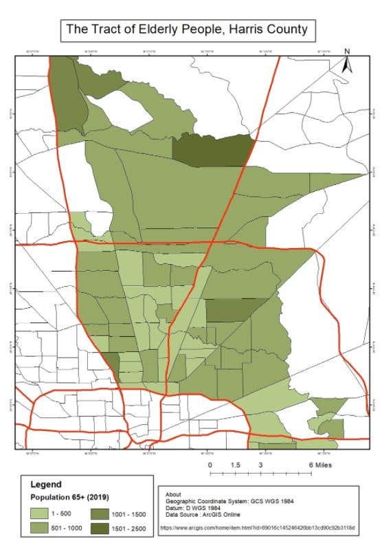

The Tracts of Elderly People, Harris County

The Tracts of Elderly People, Harris County


Maps Design
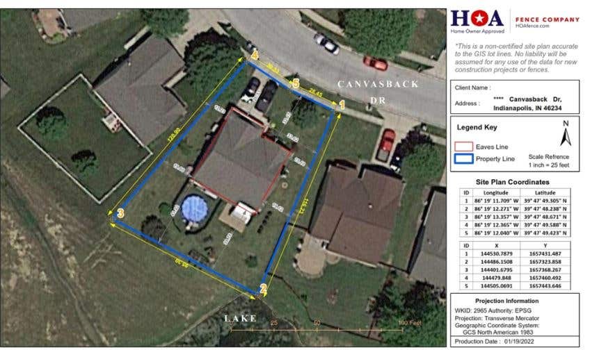

A non-certified Basic Plot Plan

A non-certified Basic Plot Plan

A non-certified Basic Plot Plan
Site Plan Illustrator for Storage Facility
Tourism Maps
Site Plan for Development Land
Site Plan for Development Land
Site Plan for Development Land
Site Plan for Development Land
Site Plan for Development Land
The Tracts of Elderly People, Harris County
The Tracts of Elderly People, Harris County
Maps Design
A non-certified Basic Plot Plan
A non-certified Basic Plot Plan
A non-certified Basic Plot Plan
Reviews
Changes saved
Showing 1 - 2 out of 2 reviews
$150.00 USD
Building Architecture
Civil Engineering
Geotechnical Engineering

•
$100.00 AUD
Cartography & Maps
Excel
Geospatial
Google Maps API
PHP

•
Experience
GIS Data Analyst & Technical Support
Sep 2017 - Present
Responsibility :
*Coordinate the acquisition of spatial data and integrates these data into well-organized GIS formats.
*Explain the values of GIS technology and processes to non-technical audiences inside Organization.
*Perform spatial analyses and creates information products from GIS and related software.
*Develop and maintains ArcGIS Online, Dashboards and Story Maps to express planning concepts and alternatives.
*Management Post Office Assets by using GIS.
GIS Data Technical Support &QA - QC Manager
Apr 2018 - Apr 2021 (3 years)
Responsibility :
*Create a car plan for field survey by MMS ( Mobile Mapping System )
*Perform and Manage Quality control and Quality Assurance according to project guidelines
*Support surveyor's activities of data collection using MMS (Mobile Mapping System LiDAR).
*Support GIS staff in the activities of Data Production (Drawing base map - Extraction Data from LiDAR point cloud).
*Check field collected data Completeness.
*Produce Daily reports of GIS activities teams.
Local GIS Focal Point
Sep 2020 - Jan 2021 (4 months, 2 days)
-Atlas and GIS maps for Fayoum, Minya and Matrouh to support the European Union Joint Rural Development Program (EU-JRDP),monitoring and evaluation
-Responsibility:
*Support activities related to maps production
*Support surveyors activities of data collection remotely than in the field using Geopaparazzi App and Check data consistency
*Support GIS staff in the activities of thematic maps and Atlas production using Q-GIS
*Solve logistic and administrative problems related to GIS activities
Education
Diploma in GIS
(1 year)
Bachelor of Arts- Geography & Geographic Information Systems (GIS)
(5 years)
Qualifications
Training Certificate in Geographic Information System (GIS) programs
Holding Company for Water and Wastewater
2012
Design Water Networks with (ARC GIS + Autodesk map)
Intermediate Certificate of American Language
Ministry of Defense Language Institute (MODLI)
2013
English course
Certificate of the training program of C# Language
The Arab Academy for Science, Technology and Maritime Transport
2015
Microsoft Visual Studio® “ C# Language”
Publications
Chart Marine Explain by Arabic
https://drive.google.com/open?id=0B4gBZhSbCEEzY3FnUXh6Ykt3THc
Explain in Chart Marine
Contact Amr S. about your job
Log in to discuss any details over chat.
Verifications
Top Skills
Browse Similar Freelancers
Browse Similar Showcases
Invite sent successfully!
Thanks! We’ve emailed you a link to claim your free credit.
Something went wrong while sending your email. Please try again.
Copy to clipboard failed, please try again after adjusting your permissions.
Copied to clipboard.
Loading preview
Permission granted for Geolocation.
Your login session has expired and you have been logged out. Please log in again.